


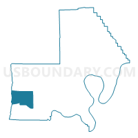
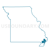
ANDERSON 1 Voting District, New Madrid County, Missouri
About
Outline

Summary
| Unique Area Identifier | 609215 |
| Name | ANDERSON 1 Voting District |
| County | New Madrid County |
| State | Missouri |
| Area (square miles) | 25.87 |
| Land Area (square miles) | 25.83 |
| Water Area (square miles) | 0.04 |
| % of Land Area | 99.86 |
| % of Water Area | 0.14 |
| Latitude of the Internal Point | 36.47353760 |
| Longtitude of the Internal Point | -89.89061090 |
Maps

Graphs
Select a template below for downloading or customizing gragh for ANDERSON 1 Voting District, New Madrid County, Missouri


Neighbors
Neighoring Voting District (by Name) Neighboring Voting District on the Map
- ANDERSON 2 Voting District, New Madrid County, MO
- Clarkton Voting District, Dunklin County, MO
- COMO 4 Voting District, New Madrid County, MO
- Malden Ward 3 & Rural, Dunklin County, MO
- PORTAGE 3 Voting District, New Madrid County, MO
Top 10 Neighboring County Subdivision (by Population) Neighboring County Subdivision on the Map
- Cotton Hill township, Dunklin County, MO (5,755)
- Portage township, New Madrid County, MO (3,752)
- Freeborn township, Dunklin County, MO (1,775)
- Como township, New Madrid County, MO (1,674)
- Anderson township, New Madrid County, MO (1,436)
Top 10 Neighboring Place (by Population) Neighboring Place on the Map
Top 10 Neighboring Unified School District (by Population) Neighboring Unified School District on the Map
- Clarkton C-4 School District, MO (1,880)
- Gideon School District, MO (1,733)
- Risco R-II School District, MO (769)